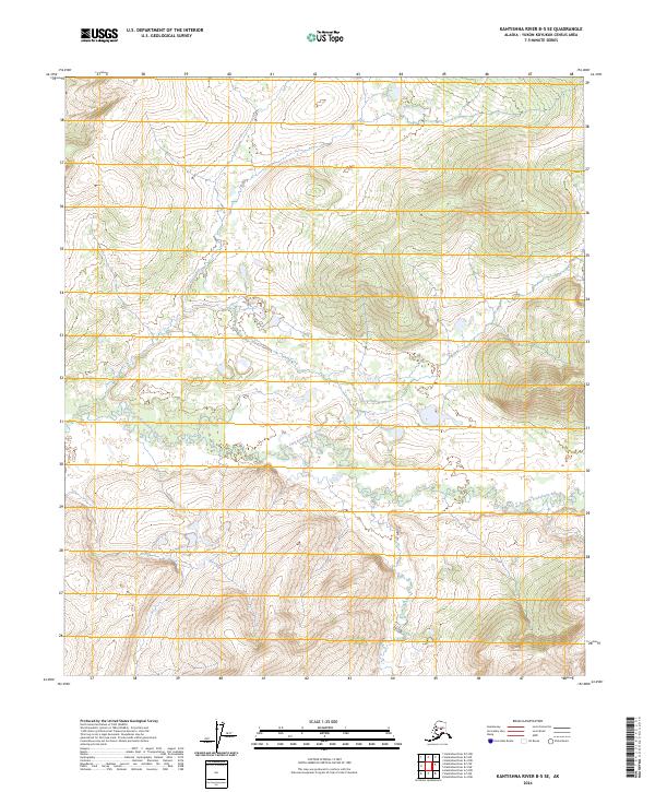
2024 Map of Kantishna River B-5 SE
USGS Topo · Published 2024About this map
North Fork Kuskokwim River meanders across the central and southern reaches of this landscape, its path defined by a series of tight oxbow loops and wetlands. The terrain is characterized by significant elevation changes, with the northern and eastern portions of the quadrangle rising into prominent hills that overlook the river valley. This 2024 edition reflects the modern topographic survey of the area within the Yukon-Koyukuk Census Area, illustrating the complex drainage patterns and natural contours of this interior Alaska wilderness. Surveyed township and range lines, including t7s r23w and t6s r23w, provide the primary grid for orientation in a region devoid of modern roads or permanent settlements on the map.
Find a feature on this map
10 named features on this map. Tap any name to fly to it.
Don’t see what you’re looking for? This feature index may not catch every label — zoom into the map to look around manually.
Map Details
Editions of this 2024 Kantishna River B-5 SE Map
This is the sole edition of this map. No revisions or reprints were ever made.
Other maps of this area

1948 · Kantishna River
USGS Topo · 1:250,000

1951 · Kantishna River
USGS Topo · 1:250,000

1952 · Kantishna River
USGS Topo · 1:250,000

1952 · Kantishna River A-5
USGS Topo · 1:63,360

1952 · Kantishna River B-5
USGS Topo · 1:63,360

1953 · Kantishna River B-4
USGS Topo · 1:63,360

1953 · Kantishna River A-4
USGS Topo · 1:63,360

1964 · Kantishna River
USGS Topo · 1:250,000
2017 · Kantishna River A-5 NE
USGS Topo · 1:25,000
2017 · Kantishna River B-5 NW
USGS Topo · 1:25,000