
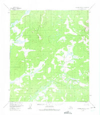
1952 Map of Kantishna River B-5
USGS Topo · Published 1957About this map
North Fork Kuskokwim River defines the southern landscape of this interior Alaskan wilderness, as seen in this 1952 aerial survey. The terrain is dominated by the high ground of Titna, where the Geological Survey utilized multiplex methods and 1954 topographic data to map the complex drainage patterns and elevation changes of the Alaska-Fourth Judicial Division. This map represents a strictly remote environment, devoid of roads, trails, or permanent settlements at the time of the survey. The intricate network of wetlands and small water bodies surrounding the river indicates a landscape heavily influenced by seasonal flooding and permafrost conditions common to the Yukon-Koyukuk region.
Find a feature on this map
2 named features on this map. Tap any name to fly to it.
Don’t see what you’re looking for? This feature index may not catch every label — zoom into the map to look around manually.
Map Details
Editions of this 1952 Kantishna River B-5 Map
2 editions found
Other maps of this area

1948 · Kantishna River
USGS Topo · 1:250,000

1951 · Kantishna River
USGS Topo · 1:250,000

1952 · Kantishna River C-5
USGS Topo · 1:63,360

1952 · Kantishna River C-6
USGS Topo · 1:63,360

1952 · Kantishna River
USGS Topo · 1:250,000

1952 · Kantishna River B-6
USGS Topo · 1:63,360

1952 · Kantishna River A-5
USGS Topo · 1:63,360

1952 · Kantishna River A-6
USGS Topo · 1:63,360

1952 · Kantishna River C-4
USGS Topo · 1:63,360

1953 · Kantishna River B-4
USGS Topo · 1:63,360