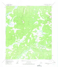
1952 Map of Kantishna River B-5
USGS Topo · Published 1975About this map
The North Fork Kuskokwim River meanders across the southern landscape of this interior Alaskan territory, defining a broad valley floor characterized by extensive wetlands and complex drainage patterns. Surveyed via aerial photography in the early 1950s, the terrain is bounded by significant uplands, including the Chitanatala Mountains to the northwest and the Bitzshtini Mountains along the eastern edge. This sheet captures a region entirely devoid of established roads or permanent settlements at the time of mapping, illustrating a pristine wilderness where topographical relief is the primary navigator. The intricate contouring reveals the transition from high mountain ridges to the low-lying basin of the North Fork Kuskokwim River, a critical waterway for this part of the Yukon-Koyukuk region.
Find a feature on this map
3 named features on this map. Tap any name to fly to it.
Don’t see what you’re looking for? This feature index may not catch every label — zoom into the map to look around manually.
Map Details
Editions of this 1952 Kantishna River B-5 Map
2 editions found
Other maps of this area

1948 · Kantishna River
USGS Topo · 1:250,000

1951 · Kantishna River
USGS Topo · 1:250,000

1952 · Kantishna River C-5
USGS Topo · 1:63,360

1952 · Kantishna River C-6
USGS Topo · 1:63,360

1952 · Kantishna River
USGS Topo · 1:250,000

1952 · Kantishna River B-6
USGS Topo · 1:63,360

1952 · Kantishna River A-5
USGS Topo · 1:63,360

1952 · Kantishna River A-6
USGS Topo · 1:63,360

1952 · Kantishna River B-5
USGS Topo · 1:63,360

1952 · Kantishna River C-4
USGS Topo · 1:63,360