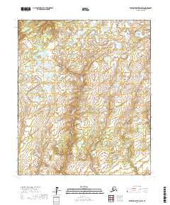
2017 Map of Kantishna River D-5 SW
USGS Topo · Published 2017About this map
The interior landscape of the Yukon-Koyukuk Census Area is meticulously documented in this 2017 study of the Kantishna River D-5 SW region. This specific quadrangle is dominated by an intricate network of wetlands and small water bodies that characterize the subarctic terrain. The mapping primarily illustrates the Public Land Survey System divisions, including T1n R24w and T1s R24w, providing a clear grid for understanding land tenure in this undeveloped stretch of Alaska. The absence of named settlements or roads underscores the wilderness character of the region, where the topography is defined more by the drainage patterns of unnamed creeks and ponds than by human infrastructure. This detailed survey, utilizing data from the Alaska Dept. of Transportation and the FWS National Wetlands Inventory, serves as a high-resolution baseline for the hydrologic and topographic state of the area in the early 21st century.
Find a feature on this map
8 named features on this map. Tap any name to fly to it.
Don’t see what you’re looking for? This feature index may not catch every label — zoom into the map to look around manually.
Map Details
Editions of this 2017 Kantishna River D-5 SW Map
This is the sole edition of this map. No revisions or reprints were ever made.
Other maps of this area

1948 · Kantishna River
USGS Topo · 1:250,000

1951 · Kantishna River
USGS Topo · 1:250,000

1952 · Kantishna River C-5
USGS Topo · 1:63,360

1952 · Kantishna River C-6
USGS Topo · 1:63,360

1952 · Kantishna River D-5
USGS Topo · 1:63,360

1952 · Kantishna River
USGS Topo · 1:250,000

1952 · Kantishna River D-6
USGS Topo · 1:63,360
1953 · Kantishna River D-5
USGS Topo · 1:63,360

1964 · Kantishna River
USGS Topo · 1:250,000
2017 · Kantishna River C-6 NE
USGS Topo · 1:25,000