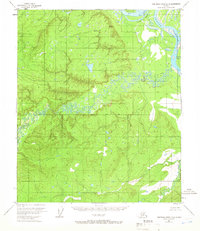
1953 Map of Kantishna River D-5
USGS Topo · Published 1966About this map
The Tanana River dominates the northeastern corner of this 1953 interior Alaska landscape, where it makes a significant turn at Harper Bend around Murray I. This environment is characterized by its complex river systems, with the heavily braided Chitanana River winding through the center of the sheet and the Cosna River cutting across the southeastern corner. The topography was established through 1952 aerial photography and 1953 field annotation, documenting a wilderness without established roads or trails. Geodetic control is marked by VABM 966 Nana, while the Fairbanks Base Line provides a primary surveying reference across the central terrain. The map's portrayal of these waterways captures the shifting hydrology of the Tanana valley before later modern developments, offering a detailed look at the drainage patterns of the Alaskan interior during the early Cold War era.
Find a feature on this map
7 named features on this map. Tap any name to fly to it.
Don’t see what you’re looking for? This feature index may not catch every label — zoom into the map to look around manually.
Map Details
Editions of this 1953 Kantishna River D-5 Map
This is the sole edition of this map. No revisions or reprints were ever made.
Other maps of this area

1948 · Kantishna River
USGS Topo · 1:250,000

1951 · Kantishna River
USGS Topo · 1:250,000

1951 · Tanana
USGS Topo · 1:250,000

1952 · Tanana A-4
USGS Topo · 1:63,360

1952 · Kantishna River C-5
USGS Topo · 1:63,360

1952 · Kantishna River C-6
USGS Topo · 1:63,360

1952 · Kantishna River D-5
USGS Topo · 1:63,360

1952 · Kantishna River
USGS Topo · 1:250,000

1952 · Tanana A-6
USGS Topo · 1:63,360

1952 · Kantishna River D-6
USGS Topo · 1:63,360