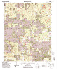
1996 Map of Karbers Ridge
USGS Topo · Published 1998About this map
Karbers Ridge serves as the central settlement on this map, which reveals the dense landscape of the eastern Shawnee hills in the late twentieth century. The area is defined by a significant concentration of local heritage sites, including the Karbers Ridge Sch and numerous community landmarks such as Good Hope Ch and Philadelphia Ch. The high density of family cemeteries, like the McPherson Cem and Sneed Cem, highlights the long-standing genealogical roots of this corner of Illinois.
Find a feature on this map
55 named features on this map. Tap any name to fly to it.
Don’t see what you’re looking for? This feature index may not catch every label — zoom into the map to look around manually.
Map Details
Editions of this 1996 Karbers Ridge Map
This is the sole edition of this map. No revisions or reprints were ever made.
Other maps of this area

1916 · Shawneetown
USGS Topo · 1:62,500

1916 · Fords Ferry
USGS Topo · 1:62,500

1916 · Golconda
USGS Topo · 1:62,500

1916 · Equality
USGS Topo · 1:62,500

1920 · Goloonda
USGS Topo · 1:48,000

1921 · Fords Ferry
USGS Topo · 1:48,000

1921 · Golconda
USGS Topo · 1:62,500

1925 · Cave In Rock
USGS Topo · 1:62,500

1949 · Paducah
USGS Topo · 1:250,000

1950 · Paducah
USGS Topo · 1:250,000