
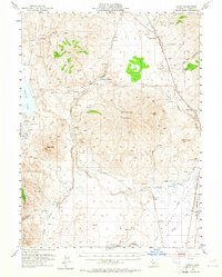
1954 Map of Karlo
USGS Topo · Published 1955About this map
Karlo sits along the Southern Pacific railroad line, serving as a focal point for this high-desert landscape in Lassen County. The 1950s terrain is defined by the massive volcanic bulk of Snowstorm Mountain and the seasonal expanse of Horse Lake to the west. Evidence of early twentieth-century ranching and infrastructure is scattered throughout the region, from the Snowstorm Ranch near the center of the sheet to the Highway Maintenance Station and an Air Strip further east.
Find a feature on this map
34 named features on this map. Tap any name to fly to it.
Don’t see what you’re looking for? This feature index may not catch every label — zoom into the map to look around manually.
Map Details
Editions of this 1954 Karlo Map
2 editions found
Other maps of this area

1886 · Honey Lake
USGS Topo · 1:250,000

1891 · Honey Lake
USGS Topo · 1:250,000

1893 · Honey Lake
USGS Topo · 1:250,000

1954 · Susanville
USGS Topo · 1:62,500

1954 · Wendel
USGS Topo · 1:62,500

1954 · Observation Peak
USGS Topo · 1:62,500

1954 · Litchfield
USGS Topo · 1:62,500

1954 · Grasshopper Valley
USGS Topo · 1:62,500

1954 · Ravendale
USGS Topo · 1:62,500

1954 · Fredonyer Peak
USGS Topo · 1:62,500