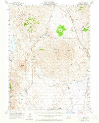
1954 Map of Karlo
USGS Topo · Published 1964About this map
The Southern Pacific railroad corridor defines the development of this high-desert landscape in Lassen County, running through the heart of the Secret Valley. The small settlement of Karlo serves as a focal point along the tracks, supported by a Water Tank and a nearby Air Strip, reflecting the logistical needs of mid-century transportation and land management. Further north, the Snowstorm Ranch sits at the base of Snowstorm Mountain, illustrating the historical ranching patterns of the region.
Find a feature on this map
40 named features on this map. Tap any name to fly to it.
Don’t see what you’re looking for? This feature index may not catch every label — zoom into the map to look around manually.
Map Details
Editions of this 1954 Karlo Map
2 editions found
Other maps of this area

1886 · Honey Lake
USGS Topo · 1:250,000

1891 · Honey Lake
USGS Topo · 1:250,000

1893 · Honey Lake
USGS Topo · 1:250,000

1954 · Susanville
USGS Topo · 1:62,500

1954 · Wendel
USGS Topo · 1:62,500

1954 · Observation Peak
USGS Topo · 1:62,500

1954 · Litchfield
USGS Topo · 1:62,500

1954 · Karlo
USGS Topo · 1:62,500

1954 · Grasshopper Valley
USGS Topo · 1:62,500

1954 · Ravendale
USGS Topo · 1:62,500