
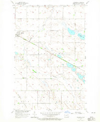
1957 Map of Karlsruhe
USGS Topo · Published 1958About this map
The Great Northern railroad cuts a diagonal path through the prairie of McHenry County, anchoring the town of Karlsruhe. This mid-century survey captures the agricultural landscape at a time when the rural school system was in transition, as evidenced by several sites like Hubbel Sch No 1 (Abandoned) and Hubbel Sch No 2 (Abandoned), while Hubbel Sch No 3 and School No 3 remained active. The meandering Wintering River and bodies of water like Herrington Lake dominate the central terrain, bordered by the distinct topography of Hogback Ridge. For genealogists, the map preserves the exact locations of local burial grounds including SS Peter and Paul Cem and Stenso Cem. The presence of numerous Gravel Pits and a Claypit suggests the local importance of aggregate and earth resources in the townships of Villard, Karlsruhe, Odin, and Balfour.
Find a feature on this map
22 named features on this map. Tap any name to fly to it.
Don’t see what you’re looking for? This feature index may not catch every label — zoom into the map to look around manually.
Map Details
Editions of this 1957 Karlsruhe Map
2 editions found
Other maps of this area

1929 · Balfour
USGS Topo · 1:62,500

1930 · Drake
USGS Topo · 1:62,500

1949 · Karlsruhe NW
USGS Topo · 1:24,000

1950 · Karlsruhe NE
USGS Topo · 1:24,000

1954 · Minot
USGS Topo · 1:250,000

1954 · McClusky
USGS Topo · 1:250,000

1955 · Rangeley NW
USGS Topo · 1:24,000

1957 · Bergen
USGS Topo · 1:24,000

1957 · Rangeley
USGS Topo · 1:24,000

1958 · McClusky
USGS Topo · 1:250,000