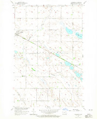
1957 Map of Karlsruhe
USGS Topo · Published 1965About this map
The small prairie community of Karlsruhe serves as the focal point of this mid-century survey, situated along the Great Northern railroad line. The landscape is defined by the winding course of the Wintering River and the prominent Hogback Ridge to the south. Local life in this McHenry County region is marked by a network of rural schoolhouses, including School No 3, Hubbel Sch No 3, and several facilities already noted as abandoned by 1957, such as Hubbel Sch No 1.
Find a feature on this map
19 named features on this map. Tap any name to fly to it.
Don’t see what you’re looking for? This feature index may not catch every label — zoom into the map to look around manually.
Map Details
Editions of this 1957 Karlsruhe Map
2 editions found
Other maps of this area

1929 · Balfour
USGS Topo · 1:62,500

1930 · Drake
USGS Topo · 1:62,500

1949 · Karlsruhe NW
USGS Topo · 1:24,000

1950 · Karlsruhe NE
USGS Topo · 1:24,000

1954 · Minot
USGS Topo · 1:250,000

1954 · McClusky
USGS Topo · 1:250,000

1955 · Rangeley NW
USGS Topo · 1:24,000

1957 · Bergen
USGS Topo · 1:24,000

1957 · Karlsruhe
USGS Topo · 1:24,000

1957 · Rangeley
USGS Topo · 1:24,000