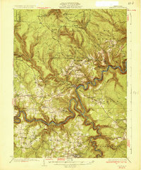
1932 Map of Karthaus
USGS Topo · Published 1932About this map
The West Branch Susquehanna River winds in deep, serpentine loops through this northern Pennsylvania landscape, where the New York Central Railroad follows the northern bank to serve remote outposts like Karthaus and Pottersdale. The 1932 edition reveals a geography defined by its narrow valley floors and ridge-top trails, including the Three Runs Trail and Number Eleven Trail. Small-scale agricultural and immigrant communities are evident in labels like German Settlement and Frenchville, the latter supported by its own Frenchville Sta. Education and faith are densely mapped across the townships, from the Buck Ram Sch in the west to Palestine Ch in the south near the Graham township line. These scattered rural schoolhouses and the Three Runs Fire Tower suggest a community-focused life and forest management in a region where topography dictated the path of every road and rail.
Find a feature on this map
99 named features on this map. Tap any name to fly to it.
Don’t see what you’re looking for? This feature index may not catch every label — zoom into the map to look around manually.
Map Details
Editions of this 1932 Karthaus Map
3 editions found

Other maps of this area

1903 · Houtzdale
USGS Topo · 1:62,500

1905 · Houtzdale
USGS Topo · 1:62,500

1908 · Bellefonte
USGS Topo · 1:62,500

1909 · Bellefonte
USGS Topo · 1:62,500

1922 · Philipsburg
USGS Topo · 1:62,500

1928 · Snow Shoe
USGS Topo · 1:48,000

1929 · Karthaus
USGS Topo · 1:62,500

1929 · Clearfield
USGS Topo · 1:48,000

1931 · Show Shoe
USGS Topo · 1:62,500

1932 · Clearfield
USGS Topo · 1:62,500
Featured Places
- Karthaus Township, PA
- Moshannon, PA
- Benezette Township, PA
- Rush Township, PA
- Rolling Stone, Covington Township