
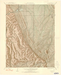
1948 Map of Kassler
USGS Topo · Published 1948About this map
Kassler and the surrounding Front Range foothills are defined here by a critical water management landscape, where the South Platte River emerges from the canyon. The Denver Board of Water Commissioners infrastructure is evident through the Filtration Pond and Reservoir near the northern boundary. This post-war era view reveals a network of small rural schoolhouses, such as Roxborough Park Sch and Indian Creek Sch, which served the scattered settlements of the Hogback and Jarre Canyon. To the east, the industrial presence of Louviers is anchored by two major rail lines: the Denver and Rio Grande Western and the Atchison Topeka and Santa Fe. The southern portion of the map transitions into the Pike National Forest, marked by the Indian Creek Ranger Sta and remote peaks like Carpenter Peak.
Find a feature on this map
30 named features on this map. Tap any name to fly to it.
Don’t see what you’re looking for? This feature index may not catch every label — zoom into the map to look around manually.
Map Details
Editions of this 1948 Kassler Map
2 editions found
Other maps of this area

1890 · East Denver
USGS Topo · 1:125,000

1893 · Platte Canyon
USGS Topo · 1:125,000

1894 · Castle Rock
USGS Topo · 1:125,000

1899 · West Denver
USGS Topo · 1:125,000

1913 · Castle Rock
USGS Topo · 1:125,000

1935 · East Denver Nos. 3 and 4
USGS Topo · 1:48,000

1940 · Castle Rock
USGS Topo · 1:62,500

1942 · Highland Ranch
USGS Topo · 1:31,680

1942 · Littleton
USGS Topo · 1:31,680

1945 · Castle Rock
USGS Topo · 1:62,500