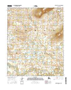
2016 Map of Kateel River D-4 NE
USGS Topo · Published 2016About this map
The S Fork Huslia River defines the southern reach of this Interior Alaska landscape, winding through a complex network of wetlands and small lakes. Surveyed in 2016, the topography is characterized by low-lying marshlands punctuated by isolated high ground, such as the prominent hills in the northeast corner of the quadrangle. The land is organized by the Public Land Survey System grids of t7n r6e, t7n r5e, t6n r6e, and t6n r5e. This remote region is largely defined by its natural water features and the absence of established road infrastructure, reflecting the wilderness character of the Yukon-Koyukuk region.
Find a feature on this map
5 named features on this map. Tap any name to fly to it.
Don’t see what you’re looking for? This feature index may not catch every label — zoom into the map to look around manually.
Map Details
Editions of this 2016 Kateel River D-4 NE Map
This is the sole edition of this map. No revisions or reprints were ever made.
Other maps of this area

1951 · Shungnak
USGS Topo · 1:250,000

1951 · Kateel River
USGS Topo · 1:250,000

1954 · Kateel River D-3
USGS Topo · 1:63,360

1954 · Kateel River D-4
USGS Topo · 1:63,360

1955 · Shungnak
USGS Topo · 1:250,000

1955 · Kateel River
USGS Topo · 1:250,000

1964 · Shungnak
USGS Topo · 1:250,000
1985 · Shungnak A-3
USGS Topo · 1:63,360
1985 · Shungnak A-4
USGS Topo · 1:63,360
2016 · Kateel River D-4 SW
USGS Topo · 1:25,000