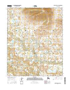
2016 Map of Kateel River D-4 NW
USGS Topo · Published 2016About this map
Glacial landforms and complex hydrology define this section of the Kateel River basin in the mid-2010s. The landscape is characterized by an extensive network of ponds, small lakes, and wetlands that fill the low-lying areas between subtle topographic rises. These water features are part of a broader interior Alaskan ecosystem where drainage patterns are often dictated by permafrost and historical glacial activity. The map encompasses portions of four townships, including T7n R4e and T7n R5e, where the terrain begins to rise more sharply in the northern reaches, reaching elevations over 1,150 feet. This transition from wet lowlands to elevated ridges reflects the diverse geomorphology typical of the Yukon-Koyukuk region, providing a baseline for environmental study and land management by the BLM and FWS.
Find a feature on this map
4 named features on this map. Tap any name to fly to it.
Don’t see what you’re looking for? This feature index may not catch every label — zoom into the map to look around manually.
Map Details
Editions of this 2016 Kateel River D-4 NW Map
This is the sole edition of this map. No revisions or reprints were ever made.
Other maps of this area

1951 · Shungnak
USGS Topo · 1:250,000

1951 · Kateel River
USGS Topo · 1:250,000

1954 · Kateel River D-4
USGS Topo · 1:63,360

1954 · Kateel River D-5
USGS Topo · 1:63,360

1955 · Shungnak
USGS Topo · 1:250,000

1955 · Kateel River
USGS Topo · 1:250,000

1964 · Shungnak
USGS Topo · 1:250,000
1985 · Shungnak A-5
USGS Topo · 1:63,360
1985 · Shungnak A-4
USGS Topo · 1:63,360
2015 · Kateel River D-5 SE
USGS Topo · 1:25,000