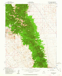
1952 Map of Kawich Peak
USGS Topo · Published 1963About this map
Silverbow and isolated outposts like Eden Creek Ranch anchor this 1952 study of the high desert landscape in Nye County. The survey illustrates a period when the United States military was significantly expanding its footprint across the Great Basin, as evidenced by the large portion of the quadrangle designated as the Las Vegas Bombing and Gunnery Range. Along the western slopes of the Kawich Range, a dedicated Mining Area near Breen Creek highlights the enduring search for mineral wealth in this arid terrain. The map also records essential water sources for cattle and transit, including Corral Spring, Summer Spring, and Cedar Spring, which were vital for survival between the high peaks of Kawich Peak and the open flats of Reveille Valley. This topography is bisected by the Mt Diablo Base Line, a fundamental surveying boundary for the Nevada territory.
Find a feature on this map
18 named features on this map. Tap any name to fly to it.
Don’t see what you’re looking for? This feature index may not catch every label — zoom into the map to look around manually.
Map Details
Editions of this 1952 Kawich Peak Map
3 editions found
Other maps of this area

1908 · Kawich
USGS Topo · 1:250,000

1942 · Cactus Range
USGS Topo · 1:125,000

1942 · Reveille Peak
USGS Topo · 1:125,000

1952 · Stinking Spring
USGS Topo · 1:62,500

1952 · Mellan
USGS Topo · 1:62,500

1952 · Kawich Peak
USGS Topo · 1:62,500

1952 · Quartzite Mtn
USGS Topo · 1:62,500

1952 · Reveille Peak
USGS Topo · 1:62,500

1952 · Belted Peak
USGS Topo · 1:62,500

1954 · Goldfield
USGS Topo · 1:250,000