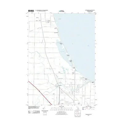
2011 Map of Kawkawlin
USGS Topo · Published 2011About this map
The coastal settlements of Saginaw Bay dominate this 2011 survey, showing a landscape defined by its connection to Lake Huron and the winding Kawkawlin River. The shoreline is tightly packed with residential developments and vacation communities, including Linwood Beach, Brissette Beach, and Lagoon Beach. In the interior, the Kawkawlin Oil Field and the North Branch Kawkawlin River illustrate the transition from the lake's industrial and recreational edge to Michigan’s agricultural and resource-rich hinterland. Significant local landmarks such as Davenport University and the Saginaw Valley Naval Ship are documented alongside vital community institutions like the Kawkawlin Post Office and Heavenly Rest Cemetery. The vast Tobico Marsh and Tobico Lagoon provide a distinct natural break between the beachfront clusters, preserving the wetlands that separate Little Killarney Beach from the more developed southern reaches near Donahue Beach.
Find a feature on this map
83 named features on this map. Tap any name to fly to it.
Don’t see what you’re looking for? This feature index may not catch every label — zoom into the map to look around manually.
Map Details
Editions of this 2011 Kawkawlin Map
This is the sole edition of this map. No revisions or reprints were ever made.
Other maps of this area

1916 · Bay City
USGS Topo · 1:62,500

1919 · Bay City
USGS Topo · 1:62,500

1943 · Bay City
USGS Topo · 1:62,500

1954 · Midland
USGS Topo · 1:250,000

1954 · Flint
USGS Topo · 1:250,000

1958 · Flint
USGS Topo · 1:250,000

1958 · Midland
USGS Topo · 1:250,000

1959 · Midland
USGS Topo · 1:250,000

1962 · Willard
USGS Topo · 1:24,000
1962 · Auburn
USGS Topo · 1:24,000