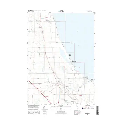
2014 Map of Kawkawlin
USGS Topo · Published 2014About this map
The western shores of Saginaw Bay are defined by a series of beach settlements and ecological preserve areas, where the land meets Lake Huron through a network of intricate drainages and marshes. The northern community of Linwood serves as a local hub, with its religious and genealogical history anchored by Saint Ann Cem and Protestant Cem. Moving south along the shoreline, the map details numerous waterfront enclaves including Linwood Beach, Killarney Beach, and Lagoon Beach, which are separated from the inland agriculture by the expansive Tobico Marsh and Tobico Lagoon. Further inland, the Kawkawlin River and its North Branch wind through the landscape toward the community of Kawkawlin. This area's infrastructure is dominated by the Lake State Railway and a complex system of managed waterways like Rosebush Drain and Millpond Drain, which reflect the region's long-standing drainage efforts for both residential development and agriculture.
Find a feature on this map
100 named features on this map. Tap any name to fly to it.
Don’t see what you’re looking for? This feature index may not catch every label — zoom into the map to look around manually.
Map Details
Editions of this 2014 Kawkawlin Map
This is the sole edition of this map. No revisions or reprints were ever made.
Other maps of this area

1916 · Bay City
USGS Topo · 1:62,500

1919 · Bay City
USGS Topo · 1:62,500

1943 · Bay City
USGS Topo · 1:62,500

1954 · Midland
USGS Topo · 1:250,000

1954 · Flint
USGS Topo · 1:250,000

1958 · Flint
USGS Topo · 1:250,000

1958 · Midland
USGS Topo · 1:250,000

1959 · Midland
USGS Topo · 1:250,000

1962 · Willard
USGS Topo · 1:24,000
1962 · Auburn
USGS Topo · 1:24,000