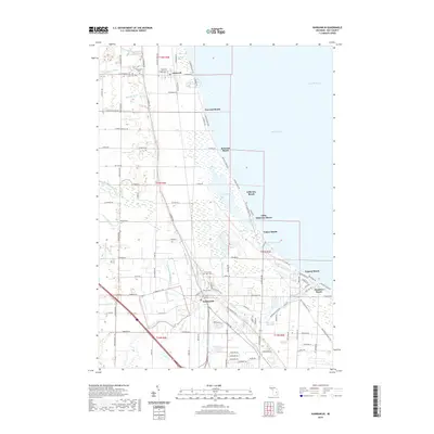
2019 Map of Kawkawlin
USGS Topo · Published 2019About this map
The Saginaw Bay shoreline of Lake Huron defines this coastal landscape, where a series of seasonal and residential beach communities line the water's edge. From Linwood Beach in the north down to Lagoon Beach and Donahue Beach in the south, the map reveals a narrow strip of development squeezed between the bay and the extensive wetlands of Tobico Marsh. The drainage of this low-lying area is managed through an intricate system of man-made channels, including the Railroad Drain, Kerr Drain, and Indian Town Drain, which feed into the larger river systems.
Find a feature on this map
111 named features on this map. Tap any name to fly to it.
Don’t see what you’re looking for? This feature index may not catch every label — zoom into the map to look around manually.
Map Details
Editions of this 2019 Kawkawlin Map
This is the sole edition of this map. No revisions or reprints were ever made.
Other maps of this area

1916 · Bay City
USGS Topo · 1:62,500

1919 · Bay City
USGS Topo · 1:62,500

1943 · Bay City
USGS Topo · 1:62,500

1954 · Midland
USGS Topo · 1:250,000

1954 · Flint
USGS Topo · 1:250,000

1958 · Flint
USGS Topo · 1:250,000

1958 · Midland
USGS Topo · 1:250,000

1959 · Midland
USGS Topo · 1:250,000

1962 · Willard
USGS Topo · 1:24,000
1962 · Auburn
USGS Topo · 1:24,000