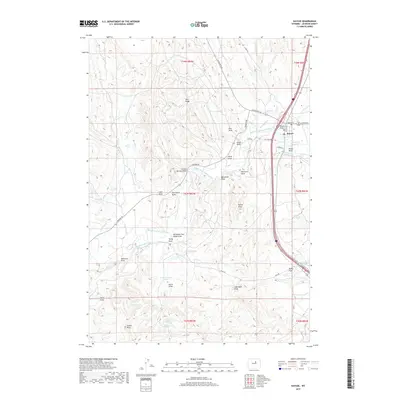
2017 Map of Kaycee
USGS Topo · Published 2017About this map
The town of Kaycee serves as the focal point of this Wyoming landscape, situated along the Middle Fork Powder River where agricultural infrastructure meets the high plains. The map reveals an intricate network of irrigation systems essential to the region's ranching economy, including the Murphy Ditch, Vruwink Ditch, and Keith Ditch. These waterways carve through a terrain defined by numerous draws and ridges, such as Pine Ridge and the prominent Castle Rock in the southwest. A series of small-scale water management features like Spratt Reservoir, Fisher Reservoir, and Keith Reservoir dot the landscape, highlighting the ongoing importance of water rights and management in Johnson County. Historical land use is suggested by family-named landmarks such as Bailey Flats and the remote Toddy Spring, while modern transportation is represented by Barnum RD and Mayoworth RD radiating from the town center.
Find a feature on this map
50 named features on this map. Tap any name to fly to it.
Don’t see what you’re looking for? This feature index may not catch every label — zoom into the map to look around manually.
Map Details
Editions of this 2017 Kaycee Map
This is the sole edition of this map. No revisions or reprints were ever made.
Other maps of this area

1955 · Arminto
USGS Topo · 1:250,000

1958 · Arminto
USGS Topo · 1:250,000

1961 · Barnum
USGS Topo · 1:62,500

1961 · Kaycee NE
USGS Topo · 1:24,000

1961 · Dry Creek Reservoir
USGS Topo · 1:24,000

1961 · TTT Ranch
USGS Topo · 1:24,000

1961 · Wall Creek
USGS Topo · 1:24,000

1961 · Hibbard Draw
USGS Topo · 1:24,000

1961 · Kaycee
USGS Topo · 1:24,000

1962 · Arminto
USGS Topo · 1:250,000