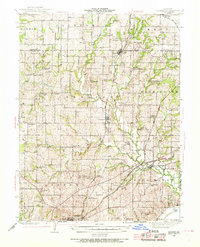
1942 Map of Kearney
USGS Topo · Published 1968About this map
Kearney serves as the central hub for this rural landscape in the 1940s, situated at the intersection of a network of secondary roads and the Chicago Burlington and Quincy railroad line. The map reveals a dense distribution of rural educational and social centers, with nearly every few miles marked by a neighborhood schoolhouse such as Mt Gilead Sch, Arley Sch, and Oakland Sch. This pattern reflects the highly localized community structure of Clay and Clinton Counties before the mid-century trend toward school consolidation changed the rural social geography.
Find a feature on this map
67 named features on this map. Tap any name to fly to it.
Don’t see what you’re looking for? This feature index may not catch every label — zoom into the map to look around manually.
Map Details
Editions of this 1942 Kearney Map
2 editions found

Other maps of this area

1890 · Kansas City
USGS Topo · 1:125,000

1894 · Kansas City
USGS Topo · 1:125,000

1894 · Independence
USGS Topo · 1:125,000

1914 · Smithville
USGS Topo · 1:62,500

1924 · Polo
USGS Topo · 1:62,500

1925 · Gower
USGS Topo · 1:62,500

1925 · Plattsburg
USGS Topo · 1:62,500

1935 · Buckner
USGS Topo · 1:24,000

1935 · Missouri City
USGS Topo · 1:24,000

1935 · North Kansas City
USGS Topo · 1:24,000