
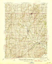
1945 Map of Kearney
USGS Topo · Published 1945About this map
The town of Kearney sits at the heart of this mid-century Missouri landscape, where the Burlington rail line intersects the rolling topography of northern Clay County. The map reveals a high density of rural institutions that once anchored these farming communities, featuring dozens of named schoolhouses such as Mt Gilead Sch, Sunny Grove Sch, and Prairie Home Sch. These small district schools and country churches like Antioch Ch illustrate a decentralized social structure before modern school consolidation reshaped the rural Midwest.
Find a feature on this map
75 named features on this map. Tap any name to fly to it.
Don’t see what you’re looking for? This feature index may not catch every label — zoom into the map to look around manually.
Map Details
Editions of this 1945 Kearney Map
2 editions found
Other maps of this area

1890 · Kansas City
USGS Topo · 1:125,000

1894 · Kansas City
USGS Topo · 1:125,000

1894 · Independence
USGS Topo · 1:125,000

1914 · Smithville
USGS Topo · 1:62,500

1924 · Polo
USGS Topo · 1:62,500

1925 · Gower
USGS Topo · 1:62,500

1925 · Plattsburg
USGS Topo · 1:62,500

1935 · Buckner
USGS Topo · 1:24,000

1935 · Missouri City
USGS Topo · 1:24,000

1935 · North Kansas City
USGS Topo · 1:24,000