
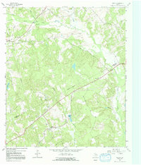
1964 Map of Keechi
USGS Topo · Published 1967About this map
Upper Keechi Creek and its many tributaries, such as Alligator Creek and Holly Branch, dominate this landscape at the boundary of Freestone and Leon Counties. The settlement of Keechi serves as a central point along the Missouri Pacific railroad, reflecting the vital role of rail transport in mid-century East Texas. The region's industrial footprint is visible through the Oakwood Dome Oil Field and scattered extraction sites like the Gravel Pit near the northern border. For those tracing family histories, the sheet is dense with local landmarks, including the Trahan Sch, Browns Chapel, and several family or community burial grounds such as Willis Cem and Plum Creek Cem. The terrain rises toward Rocky Mount, while the presence of a Gaging Sta and various drill holes indicates active resource management and geological study during the 1960s.
Find a feature on this map
28 named features on this map. Tap any name to fly to it.
Don’t see what you’re looking for? This feature index may not catch every label — zoom into the map to look around manually.
Map Details
Editions of this 1964 Keechi Map
2 editions found
Other maps of this area

1919 · Fairfield
USGS Topo · 1:62,500

1953 · Palestine
USGS Topo · 1:250,000

1954 · Waco
USGS Topo · 1:250,000

1955 · Waco
USGS Topo · 1:250,000

1956 · Jewett
USGS Topo · 1:62,500

1957 · Palestine
USGS Topo · 1:250,000

1964 · Long Lake
USGS Topo · 1:24,000

1964 · Oakwood
USGS Topo · 1:24,000

1964 · Flo
USGS Topo · 1:24,000

1964 · Lake Leon
USGS Topo · 1:24,000