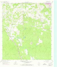
1962 Map of Keenan
USGS Topo · Published 1978About this map
Lake Creek and its southern tributaries define this portion of Montgomery County, where the transition from traditional rail-based settlements to modern water management is visible in the landscape. The area around Keenan and Karen shows the influence of multiple rail lines, including the Atchison Topeka and Santa Fe and the Chicago Rock Island and Pacific, which carved paths through the dense woodlands. For family historians, the sheet is exceptionally detailed, noting numerous small family and community burial grounds such as Yell Cem, Rabon Cartwright Cem, and the Martin Cem. The appearance of Conroe Lake in the northeastern corner signifies the era's major hydrological changes, while small, private-named water bodies like Johnson Lake and Lago del Bosque dot the interior terrain.
Find a feature on this map
31 named features on this map. Tap any name to fly to it.
Don’t see what you’re looking for? This feature index may not catch every label — zoom into the map to look around manually.
Map Details
Editions of this 1962 Keenan Map
Other maps of this area

1954 · Beaumont
USGS Topo · 1:250,000

1957 · Beaumont
USGS Topo · 1:250,000

1958 · Cowl Spur
USGS Topo · 1:24,000

1958 · Lake Paula
USGS Topo · 1:24,000

1959 · Montgomery
USGS Topo · 1:24,000

1962 · Keenan
USGS Topo · 1:24,000
1962 · Oklahoma
USGS Topo · 1:24,000

1962 · Dacus
USGS Topo · 1:24,000

1962 · Plantersville
USGS Topo · 1:24,000
1962 · Magnolia East
USGS Topo · 1:24,000