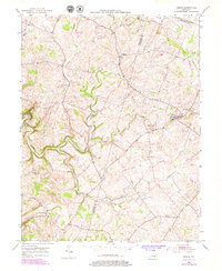
1952 Map of Keene
USGS Topo · Published 1979About this map
Clear Creek winds through the central terrain of Jessamine and Woodford counties, anchoring a rural landscape defined by scattered crossroads settlements and small country churches. This mid-century survey, updated in the late 1970s, captures the agricultural character of central Kentucky before modern development altered its footprint. Local history is preserved in sites like Dixon Town and the settlement at Keene, where the Mt Pleasant Sch and Ebenezer Ch served the surrounding farm families. The map illustrates a transition in land use, showing a Quarry and a local Landing Strip alongside older landmarks like Clover Bottom and Cave Spring. To the south, Troy stands as a focal point for the road network, while Clover Bottom Ch marks the southern reaches near the Run tributary. This record is particularly valuable for genealogists tracing family roots near these specific community centers and watercourses.
Find a feature on this map
20 named features on this map. Tap any name to fly to it.
Don’t see what you’re looking for? This feature index may not catch every label — zoom into the map to look around manually.
Map Details
Editions of this 1952 Keene Map
3 editions found
Other maps of this area

1905 · Harrodsburg
USGS Topo · 1:125,000

1906 · Georgetown
USGS Topo · 1:62,500

1908 · Georgetown
USGS Topo · 1:62,500

1922 · Frankfort
USGS Topo · 1:48,000

1924 · Frankfort
USGS Topo · 1:62,500

1950 · Lexington West
USGS Topo · 1:24,000

1952 · Keene
USGS Topo · 1:24,000

1952 · Little Hickman
USGS Topo · 1:24,000

1952 · Nicholasville
USGS Topo · 1:24,000

1952 · Harrodsburg
USGS Topo · 1:24,000