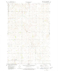
1975 Map of Keever Butte
USGS Topo · Published 1977About this map
Keever Butte rises as a prominent landmark in this central North Dakota landscape, which is divided into the rural townships of Crofte, Naughton, Hay Creek, and Gibbs. The 1970s survey captures a transition between traditional agriculture and modern infrastructure, evidenced by the presence of the Radio Towers (KBMR) standing near the butte. Small community hubs are represented by the Naughton Sch and the settlement of Arnold, while the natural drainage of the prairie is defined by the winding paths of Burnt Cr and Hay Creek. This period of land use is further marked by several Gravel Pits concentrated in the central sections, indicating the local extraction industry supporting regional road and construction projects.
Find a feature on this map
12 named features on this map. Tap any name to fly to it.
Don’t see what you’re looking for? This feature index may not catch every label — zoom into the map to look around manually.
Map Details
Editions of this 1975 Keever Butte Map
This is the sole edition of this map. No revisions or reprints were ever made.
Other maps of this area

1907 · Bismarck
USGS Topo · 1:125,000

1950 · Wilton
USGS Topo · 1:62,500

1950 · Bismarck
USGS Topo · 1:24,000

1951 · Menoken SW
USGS Topo · 1:24,000

1951 · Bismarck
USGS Topo · 1:62,500

1951 · Menoken
USGS Topo · 1:62,500

1954 · Bismarck
USGS Topo · 1:250,000

1954 · McClusky
USGS Topo · 1:250,000

1958 · Bismarck
USGS Topo · 1:250,000

1958 · McClusky
USGS Topo · 1:250,000