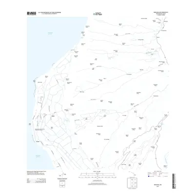
2013 Map of Kekaha
USGS Topo · Published 2013About this map
Barking Sands and the Mana Plain define the western coastal interface of Kauai on this 2013 survey. The landscape is a study in diverse land use, where the high-technology infrastructure of the Barking Sands Pacific Missile Range Facility Airport sits adjacent to the ancient sacred sites of Polihale Heiau and Kapā‘ula Heiau. The agricultural history of the region is evident in the network of reservoirs like Mānā Reservoir and Pu‘u‘ōpae Reservoir, which support the low-lying settlements of Mānā and Waieli. To the east, the terrain rises sharply into the deep ridges and valleys of Kokee State Park, where landmarks like the Pu‘uhinahina Lookout offer views over the dramatic erosional features of Hikimoe Ridge and Kā‘aweiki Valley. The map also captures the distinct coastal geography of Nohili Dune and Nohili Point.
Find a feature on this map
104 named features on this map. Tap any name to fly to it.
Don’t see what you’re looking for? This feature index may not catch every label — zoom into the map to look around manually.
Map Details
Editions of this 2013 Kekaha Map
This is the sole edition of this map. No revisions or reprints were ever made.
Other maps of this area

1954 · Kauai
USGS Topo · 1:250,000

1963 · Kekaha
USGS Topo · 1:24,000

1963 · Hanapepe
USGS Topo · 1:24,000

1965 · Waimea Canyon
USGS Topo · 1:24,000

1965 · Haena
USGS Topo · 1:24,000

1965 · Makaha Point
USGS Topo · 1:24,000

1967 · Kauai
USGS Topo · 1:250,000

1970 · Kauai
USGS Topo · 1:250,000
1977 · Hanapepe
USGS Topo · 1:24,000
1983 · Haena
USGS Topo · 1:24,000