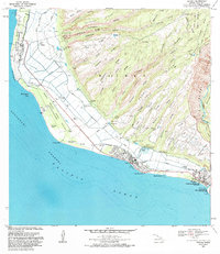
1983 Map of Kekaha
USGS Topo · Published 1984About this map
The coastal plains of southwest Kauai meet the dramatic western ridges of Waimea Canyon in this early 1980s coastal survey. The landscape is defined by the massive infrastructure of the Pacific Missile Range Facility, which stretches along the shoreline from Kokole Point north toward Mana. Inland, the economy of the era is evident in the complex system of shafts and reservoirs like the Mana Shaft, Waiawa Shaft, and Puu Opae Res, supporting the transition from the arid flats to the heavily eroded ridge system. In the southeast, the town of Waimea serves as a hub, anchored by the Waimea River and the significant cultural site at Russian Fort Elizabeth State Hist Park. The proximity of Kekaha to these mountain features, including Puehu Ridge and Puu Opae, illustrates the sharp contrast between Hawaii's specialized military-industrial zones and its deep volcanic interior.
Find a feature on this map
76 named features on this map. Tap any name to fly to it.
Don’t see what you’re looking for? This feature index may not catch every label — zoom into the map to look around manually.
Map Details
Editions of this 1983 Kekaha Map
This is the sole edition of this map. No revisions or reprints were ever made.
Other maps of this area

1954 · Kauai
USGS Topo · 1:250,000

1963 · Kekaha
USGS Topo · 1:24,000

1963 · Hanapepe
USGS Topo · 1:24,000

1965 · Waimea Canyon
USGS Topo · 1:24,000

1965 · Makaha Point
USGS Topo · 1:24,000

1967 · Kauai
USGS Topo · 1:250,000

1970 · Kauai
USGS Topo · 1:250,000
1977 · Hanapepe
USGS Topo · 1:24,000
1983 · Hanapepe
USGS Topo · 1:24,000
1983 · Makaha Point
USGS Topo · 1:24,000