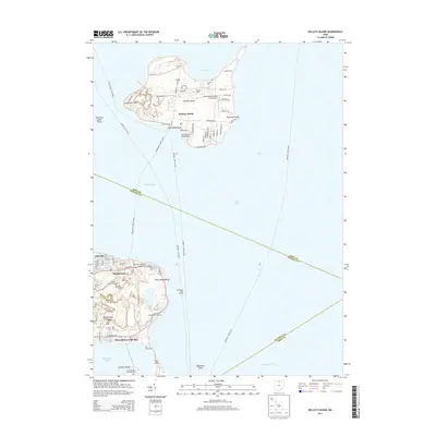
2013 Map of Kelleys Island
USGS Topo · Published 2013About this map
Lake Erie islands and the northern tip of the Marblehead Peninsula define this maritime landscape at the entrance to Sandusky Bay. On the isolated southern shore of Johnson Island, the Confederate Stockade Cem serves as a significant historical landmark, while across the South Passage on Kelleys Island, the ancient Inscription Rock remains a notable geological and cultural feature. The island's interior is marked by a network of local roads such as Division St and Ward Rd, supporting local landmarks like Camp Patmos and the Kelleys Island Land Field Airport. To the south, the village of Marblehead anchors the peninsula, surrounded by numerous specialized burial grounds including Saint Marys Byzantine Catholic Cem, Saint Josephs Cem, and Russian Cem. This coastal area is a hub of nautical activity, evidenced by Lighthouse Point Marina, Kosters Dock, and the residential community of Lakeside.
Find a feature on this map
68 named features on this map. Tap any name to fly to it.
Don’t see what you’re looking for? This feature index may not catch every label — zoom into the map to look around manually.
Map Details
Editions of this 2013 Kelleys Island Map
This is the sole edition of this map. No revisions or reprints were ever made.
Other maps of this area

1901 · Put-In-Bay
USGS Topo · 1:62,500

1901 · Bellevue
USGS Topo · 1:62,500

1903 · Bellevue
USGS Topo · 1:62,500

1903 · Put In Bay
USGS Topo · 1:62,500

1904 · Sandusky
USGS Topo · 1:62,500

1916 · Kelleys Island
USGS Topo · 1:62,500

1919 · Kelleys Island
USGS Topo · 1:62,500

1956 · Toledo
USGS Topo · 1:250,000

1959 · Sandusky
USGS Topo · 1:24,000
1959 · Huron
USGS Topo · 1:24,000