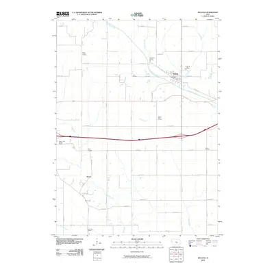
2010 Map of Kellogg
USGS Topo · Published 2010About this map
Kellogg serves as the central hub of this eastern Jasper County landscape, situated where the North Skunk River meets Coon Creek. The settlement pattern reveals a high density of rural burial sites, suggesting a deep-rooted agricultural community with distinct local identities. Notable among these are the Center Friends Cemetery, the Old German Lutheran Cemetery, and the uniquely named Our Silent City Cemetery. South of the river, small clusters of homes at Murphy and Adamsonville punctuate the grid of gravel and paved roads, while Slater Creek and Elk Creek carve through the farm country. The inclusion of the Jasper County Burying Ground and the Kellogg Post Office provides essential landmarks for those tracing family history or early township infrastructure in this part of central Iowa.
Find a feature on this map
54 named features on this map. Tap any name to fly to it.
Don’t see what you’re looking for? This feature index may not catch every label — zoom into the map to look around manually.
Map Details
Editions of this 2010 Kellogg Map
This is the sole edition of this map. No revisions or reprints were ever made.
Other maps of this area

1954 · Des Moines
USGS Topo · 1:250,000

1956 · Des Moines
USGS Topo · 1:250,000

1957 · Des Moines
USGS Topo · 1:250,000

1965 · Newton
USGS Topo · 1:24,000

1965 · Monroe
USGS Topo · 1:24,000

1969 · Des Moines
USGS Topo · 1:250,000

1975 · Baxter SE
USGS Topo · 1:24,000

1980 · Newburg
USGS Topo · 1:24,000

1980 · Sully
USGS Topo · 1:24,000
1980 · Alloway Creek
USGS Topo · 1:24,000