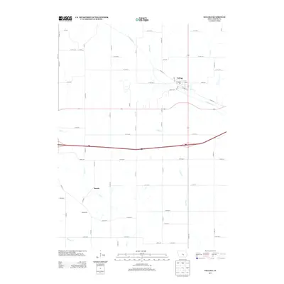
2013 Map of Kellogg
USGS Topo · Published 2013About this map
Kellogg sits at the northern confluence of the N Skunk River and Coon Cr, serving as a central hub for this portion of Jasper County. The landscape is defined by the drainage patterns of several tributaries, including Burr Oak Cr and Slater Cr, which carve through the agricultural grid. To the south, the smaller settlements of Murphy and Adamsonville appear as distinct points along the rural road network, reflecting the enduring pattern of decentralized farming communities in central Iowa. This 2013 survey highlights the modern infrastructure overlaying these established locales, notably the corridor of Interstate 80 and the local presence of the Kellogg RV Park near the river. The map provides a precise look at property-access roads such as Inlet Ave and Slater Cr, offering genealogists and local historians a clear view of how these small-town centers and rural tracts were organized in the early twenty-first century.
Find a feature on this map
64 named features on this map. Tap any name to fly to it.
Don’t see what you’re looking for? This feature index may not catch every label — zoom into the map to look around manually.
Map Details
Editions of this 2013 Kellogg Map
This is the sole edition of this map. No revisions or reprints were ever made.
Other maps of this area

1954 · Des Moines
USGS Topo · 1:250,000

1956 · Des Moines
USGS Topo · 1:250,000

1957 · Des Moines
USGS Topo · 1:250,000

1965 · Newton
USGS Topo · 1:24,000

1965 · Monroe
USGS Topo · 1:24,000

1969 · Des Moines
USGS Topo · 1:250,000

1975 · Baxter SE
USGS Topo · 1:24,000

1980 · Newburg
USGS Topo · 1:24,000

1980 · Sully
USGS Topo · 1:24,000
1980 · Alloway Creek
USGS Topo · 1:24,000