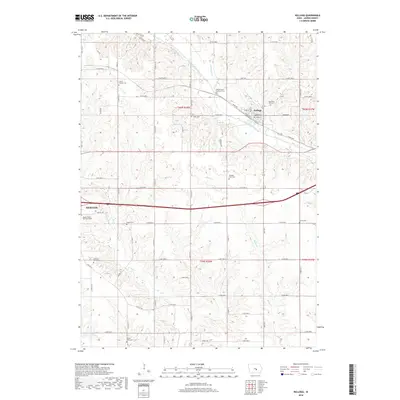
2018 Map of Kellogg
USGS Topo · Published 2018About this map
The North Skunk River meanders across this portion of Jasper County, defining the agricultural landscape just east of Newton. The settlement of Kellogg serves as a central hub, situated where the river valley meets a grid of rural roads and the tracks of the railroad. The area is notable for its high density of small, family, or denominational burial grounds, which offer a look at the early settlement patterns of the region. Notable sites include the Center Friends Cem, reflecting the area's Quaker heritage, and the Old German Lutheran Cem. From the Jasper County Burying Ground in the west to Saums Cem in the east, these landmarks provide significant touchpoints for genealogical research. The terrain is further etched by numerous tributaries such as Slater Cr and Burr Oak Cr, which cut through the rolling Iowa farmland.
Find a feature on this map
75 named features on this map. Tap any name to fly to it.
Don’t see what you’re looking for? This feature index may not catch every label — zoom into the map to look around manually.
Map Details
Editions of this 2018 Kellogg Map
This is the sole edition of this map. No revisions or reprints were ever made.
Other maps of this area

1954 · Des Moines
USGS Topo · 1:250,000

1956 · Des Moines
USGS Topo · 1:250,000

1957 · Des Moines
USGS Topo · 1:250,000

1965 · Newton
USGS Topo · 1:24,000

1965 · Monroe
USGS Topo · 1:24,000

1969 · Des Moines
USGS Topo · 1:250,000

1975 · Baxter SE
USGS Topo · 1:24,000

1980 · Newburg
USGS Topo · 1:24,000

1980 · Sully
USGS Topo · 1:24,000
1980 · Alloway Creek
USGS Topo · 1:24,000