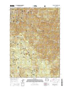
2014 Map of Kelsay Butte
USGS Topo · Published 2014About this map
Umatilla National Forest encompasses this high-elevation terrain where the headwaters of numerous creeks converge toward the North Fork John Day River. The landscape is defined by its drainages and peaks, with Kelsay Butte and Winom Butte serving as primary landmarks. Small, named openings in the timber, such as Kelsay Meadows and Lost Horse Meadow, suggest areas historically significant for grazing or backcountry passage. A complex network of forest roads, including Natl Forest Develop Road 1012 RD and Natl Forest Develop Road 1010 RD, provides access across the ridge lines. Water sources like Kelsay Spring and Handy Spring are essential features for those navigating these slopes. The boundary between Umatilla and Grant counties cuts across the northern section of the sheet, dividing this remote portion of the Blue Mountains.
Find a feature on this map
40 named features on this map. Tap any name to fly to it.
Don’t see what you’re looking for? This feature index may not catch every label — zoom into the map to look around manually.
Map Details
Editions of this 2014 Kelsay Butte Map
This is the sole edition of this map. No revisions or reprints were ever made.
Other maps of this area

1951 · Dale
USGS Topo · 1:62,500

1951 · Desolation Butte
USGS Topo · 1:62,500

1953 · Pendleton
USGS Topo · 1:250,000

1955 · Canyon City
USGS Topo · 1:250,000

1956 · Pendleton
USGS Topo · 1:250,000

1959 · Canyon City
USGS Topo · 1:250,000

1967 · Ukiah SE
USGS Topo · 1:24,000

1967 · Tower Mtn
USGS Topo · 1:24,000

1967 · Pearson Ridge
USGS Topo · 1:24,000
1979 · La Grande
USGS Topo · 1:100,000