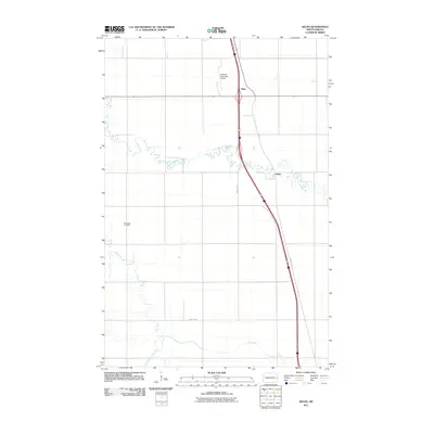
2011 Map of Kelso
USGS Topo · Published 2011About this map
The North Branch Elm River and Elm River meander through the flat, agricultural landscape of Traill County, dictating the sparse settlement patterns seen in the early 21st century. The map centers on the small unincorporated communities of Kelso and Alton, which are connected by a primary north-south transport corridor. While modern infrastructure like County Hwy-81 and the Hillsboro Municipal Airport serve the region, older local landmarks such as the Bohnsack Cemetery reflect the long-standing rural community ties. The sectioning of the land into rigid grids, interrupted only by the winding paths of the South Branch Elm River, highlights the deep-rooted prairie farming tradition that continues to shape this corner of North Dakota.
Find a feature on this map
10 named features on this map. Tap any name to fly to it.
Don’t see what you’re looking for? This feature index may not catch every label — zoom into the map to look around manually.
Map Details
Editions of this 2011 Kelso Map
This is the sole edition of this map. No revisions or reprints were ever made.
Other maps of this area

1918 · Kelso
USGS Topo · 1:62,500

1918 · Hendrum
USGS Topo · 1:62,500

1943 · Kelso
USGS Topo · 1:62,500

1952 · Grand Forks
USGS Topo · 1:250,000

1956 · Grand Forks
USGS Topo · 1:250,000

1963 · Gardner
USGS Topo · 1:24,000

1963 · Hillsboro
USGS Topo · 1:24,000

1963 · Kelso
USGS Topo · 1:24,000

1963 · Halstad SW
USGS Topo · 1:24,000
1964 · Caledonia
USGS Topo · 1:24,000