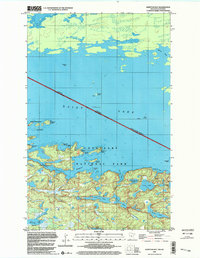
1999 Map of Kempton Bay
USGS Topo · Published 2003About this map
Voyageurs National Park encompasses the southern portion of this border region, where the intricate shoreline of Kempton Bay meets the vast waters of Rainy Lake. The map details a complex labyrinth of islands and channels along the international boundary between Ontario and Minnesota. Significant landmasses like Big Island and Emerald Island sit north of the mainland, while the interior terrain is dotted with secluded water bodies such as Fishmouth Lake, Oslo Lake, and Cruiser Lake.
Find a feature on this map
37 named features on this map. Tap any name to fly to it.
Don’t see what you’re looking for? This feature index may not catch every label — zoom into the map to look around manually.
Map Details
Editions of this 1999 Kempton Bay Map
This is the sole edition of this map. No revisions or reprints were ever made.
Other maps of this area

1954 · International Falls
USGS Topo · 1:250,000

1957 · International Falls
USGS Topo · 1:250,000

1958 · International Falls
USGS Topo · 1:250,000

1967 · Namakan Island
USGS Topo · 1:24,000

1967 · Kempton Bay
USGS Topo · 1:24,000
1967 · Kettle Falls
USGS Topo · 1:24,000

1968 · Soldier Point
USGS Topo · 1:24,000

1968 · Daley Bay
USGS Topo · 1:24,000

1968 · Ash River NE
USGS Topo · 1:24,000
1978 · Brule Narrows
USGS Topo · 1:100,000