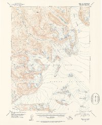
1952 Map of Kenai A-1
USGS Topo · Published 1954About this map
The Kenai National Moose Range occupies a significant portion of this terrain, showcasing a landscape dominated by massive glacial systems in the early 1950s. The southeastern portion of the map is defined by the expansive Harding Ice Field, which feeds several major frozen tributaries including Skilak Glacier, Killey Glacier, and Indian Glacier. These glaciers are meticulously mapped with blue contour lines and specific notations for numerous crevasses, indicating the dynamic and hazardous nature of the ice at mid-century. Drainage from these heights forms the Killey River and Indian Creek, while isolated water bodies like Iceberg Lake are captured at the edges of the retreating ice. This survey reflects the remote character of the Kenai Peninsula before modern infrastructure, focusing entirely on the natural hydrology and topographical elevations that define this subarctic wilderness.
Find a feature on this map
10 named features on this map. Tap any name to fly to it.
Don’t see what you’re looking for? This feature index may not catch every label — zoom into the map to look around manually.
Map Details
Editions of this 1952 Kenai A-1 Map
2 editions found

Other maps of this area

1944 · Kenai
USGS Topo · 1:250,000

1946 · Blying Sound
USGS Topo · 1:250,000

1950 · Kenai
USGS Topo · 1:250,000

1950 · Kenai B-1
USGS Topo · 1:63,360

1950 · Seldovia D-2
USGS Topo · 1:63,360

1950 · Seward A-8
USGS Topo · 1:63,360

1951 · Blying Sound
USGS Topo · 1:250,000

1951 · Seward
USGS Topo · 1:250,000

1951 · Seldovia
USGS Topo · 1:250,000

1951 · Kenai B-2
USGS Topo · 1:63,360