
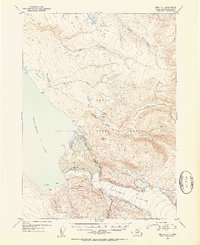
1952 Map of Kenai A-2
USGS Topo · Published 1954About this map
Kenai National Moose Range dominates this mid-century survey of the Kenai Peninsula, showcasing a wilderness landscape largely defined by glacial activity and remote outposts. The southeastern portion of the map is anchored by the massive Tustumena Glacier, which feeds into the eastern reaches of Tustumena Lake. Several remote Cabins are positioned along the shoreline and interior valleys, suggesting the presence of seasonal trappers, hunters, or early forest service stations. A dense network of waterways, including the Funny River, Bear Creek, and Indian Creek, drain the high country toward the lake. The terrain is marked by significant elevations like Vabm 2823 Glacier, illustrating the transition from ice fields to the wooded lowlands of the Moose Range. This map captures the region in its raw, undeveloped state shortly after the end of the second World War.
Find a feature on this map
15 named features on this map. Tap any name to fly to it.
Don’t see what you’re looking for? This feature index may not catch every label — zoom into the map to look around manually.
Map Details
Editions of this 1952 Kenai A-2 Map
2 editions found
Other maps of this area

1944 · Kenai
USGS Topo · 1:250,000

1950 · Kenai
USGS Topo · 1:250,000

1950 · Kenai B-1
USGS Topo · 1:63,360

1950 · Seldovia D-2
USGS Topo · 1:63,360

1950 · Kenai B-3
USGS Topo · 1:63,360

1951 · Seldovia
USGS Topo · 1:250,000

1951 · Seldovia D-3
USGS Topo · 1:63,360

1951 · Kenai B-2
USGS Topo · 1:63,360

1951 · Kenai A-3
USGS Topo · 1:63,360

1951 · Kenai A-2
USGS Topo · 1:63,360