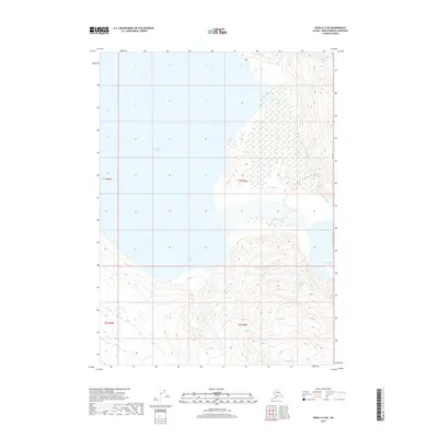
2017 Map of Kenai A-2 SW
USGS Topo · Published 2017About this map
Tustumena Lake dominates the northwestern portion of this 2017 survey, where glacial waters meet the steep, carved terrain of the Kenai Peninsula. The landscape is defined by the massive Tustumena Glacier in the southeast, whose presence dictates the drainage patterns of the surrounding highlands. This glacial influence is evident in the network of tributary waters, including Indian Cr to the north and the converging flows of Crystal Cr and Clear Cr in the southern valleys. The irregular shoreline of Devils Bay provides a protected indentation on the lake's southern edge, illustrating the complex intersection of ice-sculpted land and freshwater. This document records a largely wild, unpopulated environment during the early 21st century, focusing on the hydraulic and geological relationship between the ice fields and the peninsula's largest lake.
Find a feature on this map
11 named features on this map. Tap any name to fly to it.
Don’t see what you’re looking for? This feature index may not catch every label — zoom into the map to look around manually.
Map Details
Editions of this 2017 Kenai A-2 SW Map
This is the sole edition of this map. No revisions or reprints were ever made.
Other maps of this area

1944 · Kenai
USGS Topo · 1:250,000

1950 · Kenai
USGS Topo · 1:250,000

1950 · Seldovia D-2
USGS Topo · 1:63,360

1951 · Seldovia
USGS Topo · 1:250,000

1951 · Seldovia D-3
USGS Topo · 1:63,360

1951 · Kenai A-3
USGS Topo · 1:63,360

1951 · Kenai A-2
USGS Topo · 1:63,360

1952 · Kenai A-2
USGS Topo · 1:63,360

1952 · Kenai A-3
USGS Topo · 1:63,360

1953 · Seldovia D-2
USGS Topo · 1:63,360