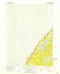
1952 Map of Kenai A-5
USGS Topo · Published 1954About this map
Ninilchik sits along the western shoreline of the Kenai Peninsula, where the Ninilchik River and Deep Creek meet the waters of Cook Inlet. This early 1950s survey captures the region as the Sterling Highway provided critical overland access through the coastal terrain. The settlement pattern reveals the intersection of transportation and local industry, featuring the Ninilchik Landing Strip and a Gravel Pit near the coast. Further inland, the presence of Jackinsky Ranch highlights the early homesteading and ranching activity that defined this stretch of the peninsula. The map also delineates the Seward Base Line, a fundamental surveying boundary for Southcentral Alaska, providing a structural look at how the land was organized for development just south of Cape Ninilchik.
Find a feature on this map
10 named features on this map. Tap any name to fly to it.
Don’t see what you’re looking for? This feature index may not catch every label — zoom into the map to look around manually.
Map Details
Editions of this 1952 Kenai A-5 Map
2 editions found

Other maps of this area

1944 · Kenai
USGS Topo · 1:250,000

1946 · Seldovia D-5
USGS Topo · 1:63,360

1949 · Seldovia D-4
USGS Topo · 1:63,360

1950 · Kenai
USGS Topo · 1:250,000

1951 · Seldovia D-5
USGS Topo · 1:63,360

1951 · Seldovia D-4
USGS Topo · 1:63,360

1951 · Seldovia
USGS Topo · 1:250,000

1951 · Kenai A-5
USGS Topo · 1:63,360

1951 · Kenai B-4
USGS Topo · 1:63,360

1951 · Kenai A-4
USGS Topo · 1:63,360