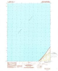
1987 Map of Kenai A-5 NE
USGS Topo · Published 1987About this map
Cook Inlet dominates this coastal survey, occupying nearly the entire expanse of the map area. Along the southeastern shoreline, the terrain transitions to a narrow coastal strip marked by numerous Rock formations and tidal details. This segment of the Kenai Peninsula coastline reflects the infrastructure of the mid-1980s, featuring a Trans Line that parallels the coast, indicating the region's utilities and power distribution during this period. A primary survey marker, the Base Line, intersects this coastal corridor, while BM 70.1 provides a specific vertical datum point for topographical reference. The map primarily documents the shoreline's edge and the immediate inland developments that follow the natural curve of the inlet.
Find a feature on this map
5 named features on this map. Tap any name to fly to it.
Don’t see what you’re looking for? This feature index may not catch every label — zoom into the map to look around manually.
Map Details
Editions of this 1987 Kenai A-5 NE Map
This is the sole edition of this map. No revisions or reprints were ever made.
Other maps of this area

1944 · Kenai
USGS Topo · 1:250,000

1950 · Kenai
USGS Topo · 1:250,000

1951 · Kenai A-5
USGS Topo · 1:63,360

1951 · Kenai B-4
USGS Topo · 1:63,360

1951 · Kenai A-4
USGS Topo · 1:63,360

1952 · Kenai A-5
USGS Topo · 1:63,360

1952 · Kenai B-4
USGS Topo · 1:63,360

1952 · Kenai A-4
USGS Topo · 1:63,360

1958 · Kenai
USGS Topo · 1:250,000
1986 · Kenai B-4 SW
USGS Topo · 1:25,000