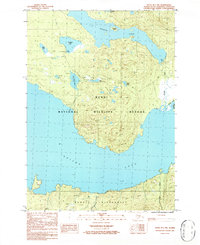
1986 Map of Kenai B-1 NW
USGS Topo · Published 1986About this map
The Kenai National Wildlife Refuge dominates this mid-1980s topographic survey, capturing a pristine aquatic landscape of the Kenai Peninsula before significant modern development. The map details a complex network of glacial and freshwater bodies, including the expansive Hidden Lake with its centrally located Explorer Island, and the northern reaches of Skilak Lake. A managed wilderness character is evident through the inclusion of several campgrounds and a Boat Ramp, alongside smaller named waters like Chatelain Lake and Engineer Lake. Evidence of human movement through this backcountry is preserved via the Pack Trail winding through the terrain, while the Kenai River and Kenai Wilderness boundaries mark the eastern and southern margins of the study area, reflecting the dual priorities of recreation and conservation in this era.
Find a feature on this map
21 named features on this map. Tap any name to fly to it.
Don’t see what you’re looking for? This feature index may not catch every label — zoom into the map to look around manually.
Map Details
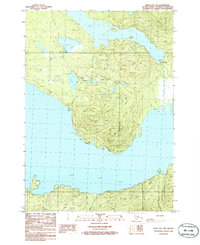
Editions of this 1986 Kenai B-1 NW Map
2 editions found
Other maps of this area

1944 · Kenai
USGS Topo · 1:250,000

1950 · Kenai
USGS Topo · 1:250,000

1950 · Kenai B-1
USGS Topo · 1:63,360

1951 · Kenai B-2
USGS Topo · 1:63,360

1951 · Kenai C-1
USGS Topo · 1:63,360

1951 · Kenai C-2
USGS Topo · 1:63,360

1952 · Kenai C-1
USGS Topo · 1:63,360

1952 · Kenai C-2
USGS Topo · 1:63,360

1952 · Kenai B-2
USGS Topo · 1:63,360

1952 · Kenai B-1
USGS Topo · 1:63,360