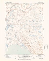
1952 Map of Kenai B-3
USGS Topo · Published 1954About this map
Soldotna and the surrounding central Kenai Peninsula are captured here in the early 1950s, shortly after the community's establishment as a homesteading hub. The settlement is centered near the intersection of the Sterling Highway and the Kenai River, showing the early road network and bridge crossing that facilitated rapid growth in the post-war era. The vast majority of the landscape is dominated by the Kenai National Moose Range, characterized by an intricate network of wetlands, small lakes, and stream systems like Slikok Creek and Soldotna Cr. To the south, the massive shoreline of Tustumena Lake anchors the map, while several Cabin sites are tucked away along remote riverbanks and trails. The map documents the region's character as a frontier crossroad before the discovery of oil and subsequent industrial expansion transformed the peninsula's economy.
Find a feature on this map
12 named features on this map. Tap any name to fly to it.
Don’t see what you’re looking for? This feature index may not catch every label — zoom into the map to look around manually.
Map Details
Editions of this 1952 Kenai B-3 Map
3 editions found

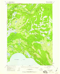
Other maps of this area

1944 · Kenai
USGS Topo · 1:250,000

1950 · Kenai
USGS Topo · 1:250,000

1950 · Kenai C-3
USGS Topo · 1:63,360

1950 · Kenai B-3
USGS Topo · 1:63,360

1951 · Kenai B-2
USGS Topo · 1:63,360

1951 · Kenai C-2
USGS Topo · 1:63,360

1951 · Kenai A-3
USGS Topo · 1:63,360

1951 · Kenai A-2
USGS Topo · 1:63,360

1951 · Kenai C-4
USGS Topo · 1:63,360

1951 · Kenai C-3
USGS Topo · 1:63,360