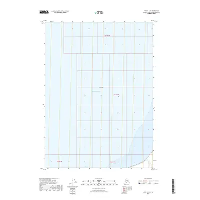
2018 Map of Kenai B-4 NW
USGS Topo · Published 2018About this map
Cook Inlet and the Pacific Ocean dominate this coastal section of the Kenai Peninsula, where the landscape is defined by the shifting interface of water and land. The maritime character of the region is anchored by Karluk Reef, a significant underwater feature located offshore. On the narrow strip of land visible in the southeastern corner, Cohoe Beach Road provides the primary terrestrial access, tracing the shoreline just inland from the beach. This 2018 survey illustrates the Public Land Survey System grid across the water and coastal margins, including portions of t5n r12w and t4n r12w. The map serves as a clear record of the peninsula's coastal geometry before further erosion or development alters this section of the beach.
Find a feature on this map
9 named features on this map. Tap any name to fly to it.
Don’t see what you’re looking for? This feature index may not catch every label — zoom into the map to look around manually.
Map Details
Editions of this 2018 Kenai B-4 NW Map
This is the sole edition of this map. No revisions or reprints were ever made.
Other maps of this area

1944 · Kenai
USGS Topo · 1:250,000

1950 · Kenai
USGS Topo · 1:250,000

1951 · Kenai C-4
USGS Topo · 1:63,360

1951 · Kenai B-4
USGS Topo · 1:63,360

1952 · Kenai C-4
USGS Topo · 1:63,360

1952 · Kenai B-4
USGS Topo · 1:63,360

1958 · Kenai C-5
USGS Topo · 1:63,360

1958 · Kenai
USGS Topo · 1:250,000
1986 · Kenai B-4 NW
USGS Topo · 1:25,000
1986 · Kenai B-4 SW
USGS Topo · 1:25,000