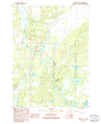
1986 Map of Kenai B-4 SE
USGS Topo · Published 1986About this map
The Kasilof River winds through this 1986 survey of the Kenai Peninsula, carving a path through wetlands and dense woodlands as it flows toward Cook Inlet. The settlement of Kasilof and the nearby community of Cohoe serve as the primary human anchors on the western edge of the sheet, while the eastern portion is dominated by the Kenai National Wildlife Refuge. This wilderness interface is defined by the river’s complex hydraulics, including Moosehead Rapids, Silver Salmon Rapids, and the sharp turn at Hongkong Bend. Numerous water bodies like Johnson Lake and Pollard Lake dot the landscape, indicating a high water table and a terrain shaped by glacial recession. To the south, the map reaches the northern shores of Tustumena Lake, revealing a remote Alaskan environment where only a Winter Trail and scattered landing strips provide access far beyond the primary roads.
Find a feature on this map
25 named features on this map. Tap any name to fly to it.
Don’t see what you’re looking for? This feature index may not catch every label — zoom into the map to look around manually.
Map Details
Editions of this 1986 Kenai B-4 SE Map
This is the sole edition of this map. No revisions or reprints were ever made.
Other maps of this area

1944 · Kenai
USGS Topo · 1:250,000

1950 · Kenai
USGS Topo · 1:250,000

1950 · Kenai B-3
USGS Topo · 1:63,360

1951 · Kenai A-3
USGS Topo · 1:63,360

1951 · Kenai B-4
USGS Topo · 1:63,360

1951 · Kenai A-4
USGS Topo · 1:63,360

1952 · Kenai B-3
USGS Topo · 1:63,360

1952 · Kenai B-4
USGS Topo · 1:63,360

1952 · Kenai A-3
USGS Topo · 1:63,360

1952 · Kenai A-4
USGS Topo · 1:63,360