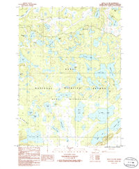
1986 Map of Kenai C-2 NW
USGS Topo · Published 1986About this map
The Swanson River meanders through the northwest corner of this sub-arctic landscape, defining a complex hydrologic network protected within the Kenai National Wildlife Refuge. This mid-1980s provisional survey illustrates a dense concentration of glacially formed kettle lakes and interconnected waterways, including the distinctively named Sucker Lake, Canoe Lake, and Ice Lake. The southern half of the map is designated as the Kenai Wilderness, where the lack of roads emphasizes the region's reliance on river corridors and trails for movement. Local geographic nomenclature, such as Doghouse Lake and Skookum Lake, reflects the cultural layers of the Kenai Peninsula. This document preserves the intricate shoreline details of smaller bodies of water like Big Merganser Lake and Duckbill Lake before contemporary changes in the water table altered these fragile ecosystems.
Find a feature on this map
41 named features on this map. Tap any name to fly to it.
Don’t see what you’re looking for? This feature index may not catch every label — zoom into the map to look around manually.
Map Details
Editions of this 1986 Kenai C-2 NW Map
This is the sole edition of this map. No revisions or reprints were ever made.
Other maps of this area

1944 · Kenai
USGS Topo · 1:250,000

1950 · Kenai
USGS Topo · 1:250,000

1950 · Kenai C-3
USGS Topo · 1:63,360

1951 · Kenai D-3
USGS Topo · 1:63,360

1951 · Kenai C-2
USGS Topo · 1:63,360

1951 · Kenai D-2
USGS Topo · 1:63,360

1951 · Kenai C-3
USGS Topo · 1:63,360

1952 · Kenai D-3
USGS Topo · 1:63,360

1952 · Kenai D-2
USGS Topo · 1:63,360

1952 · Kenai C-2
USGS Topo · 1:63,360