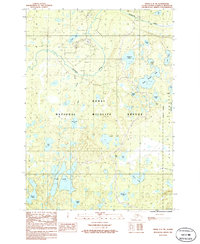
1986 Map of Kenai C-3 NE
USGS Topo · Published 1986About this map
The Kenai National Wildlife Refuge dominates this mid-1980s terrain, revealing a landscape defined by an intricate network of kettle lakes and the winding Swanson River. This specific portion of the peninsula showcases the intersection of conservation and resource extraction, with an active Oil Field and Gravel Pit situated just north of the Wilderness Boundary. Local navigation and accessibility are marked by a Landing Strip and a Radio Tower near Hungry Lake.
Find a feature on this map
33 named features on this map. Tap any name to fly to it.
Don’t see what you’re looking for? This feature index may not catch every label — zoom into the map to look around manually.
Map Details
Editions of this 1986 Kenai C-3 NE Map
This is the sole edition of this map. No revisions or reprints were ever made.
Other maps of this area

1944 · Kenai
USGS Topo · 1:250,000

1950 · Kenai
USGS Topo · 1:250,000

1950 · Kenai C-3
USGS Topo · 1:63,360

1951 · Kenai D-3
USGS Topo · 1:63,360

1951 · Kenai C-2
USGS Topo · 1:63,360

1951 · Kenai D-2
USGS Topo · 1:63,360

1951 · Kenai C-3
USGS Topo · 1:63,360

1952 · Kenai D-3
USGS Topo · 1:63,360

1952 · Kenai D-2
USGS Topo · 1:63,360

1952 · Kenai C-2
USGS Topo · 1:63,360