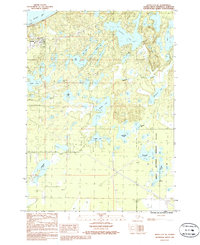
1986 Map of Kenai C-4 NE
USGS Topo · Published 1986About this map
Nikiski stands as the primary hub of development on this portion of the Kenai Peninsula, characterized by its industrial and infrastructure markers during the mid-1980s. The settlement's proximity to Nikiski Bay is supported by a network of utility and transport corridors, including a Pipeline and multiple Transmission Line routes that cut across the complex lacustrine environment. To the east, the landscape transitions into the protected expanse of the Kenai National Wildlife Refuge, where human impact is replaced by a dense concentration of named water bodies.
Find a feature on this map
29 named features on this map. Tap any name to fly to it.
Don’t see what you’re looking for? This feature index may not catch every label — zoom into the map to look around manually.
Map Details
Editions of this 1986 Kenai C-4 NE Map
This is the sole edition of this map. No revisions or reprints were ever made.
Other maps of this area

1944 · Kenai
USGS Topo · 1:250,000

1950 · Kenai
USGS Topo · 1:250,000

1950 · Kenai C-3
USGS Topo · 1:63,360

1950 · Kenai D-4
USGS Topo · 1:63,360

1951 · Kenai D-3
USGS Topo · 1:63,360

1951 · Kenai C-4
USGS Topo · 1:63,360

1951 · Kenai C-3
USGS Topo · 1:63,360

1952 · Kenai D-3
USGS Topo · 1:63,360

1952 · Kenai D-4
USGS Topo · 1:63,360

1952 · Kenai C-4
USGS Topo · 1:63,360