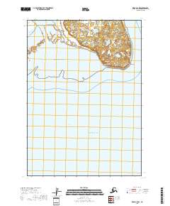
2018 Map of Kenai C-5 NW
USGS Topo · Published 2018About this map
Kustatan sits along the shoreline of the Pacific Ocean, overlooking the waters of Cook Inlet in this coastal region of the Kenai Peninsula. The landscape is defined by the prominent West Foreland promontory, which separates the expansive Redoubt Bay to the south from Trading Bay to the north. This coastal interface illustrates the tidal and geological transition between the mudflats and the upland terrain of the peninsula.
Find a feature on this map
11 named features on this map. Tap any name to fly to it.
Don’t see what you’re looking for? This feature index may not catch every label — zoom into the map to look around manually.
Map Details
Editions of this 2018 Kenai C-5 NW Map
This is the sole edition of this map. No revisions or reprints were ever made.
Other maps of this area

1944 · Kenai
USGS Topo · 1:250,000

1950 · Kenai
USGS Topo · 1:250,000

1958 · Kenai C-5
USGS Topo · 1:63,360

1958 · Kenai D-5
USGS Topo · 1:63,360

1958 · Kenai C-6
USGS Topo · 1:63,360

1958 · Kenai D-6
USGS Topo · 1:63,360

1958 · Kenai
USGS Topo · 1:250,000
2018 · Kenai C-6 SE
USGS Topo · 1:25,000
2018 · Kenai C-6 NE
USGS Topo · 1:25,000
2018 · Kenai D-6 SE
USGS Topo · 1:25,000