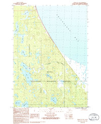
1986 Map of Kenai D-1 NW
USGS Topo · Published 1986About this map
The Kenai National Wildlife Refuge and the Kenai Wilderness dominate this northern portion of the Kenai Peninsula, where the land meets the tidal flats of Chickaloon Bay. This 1986 survey depicts a complex lacustrine environment, defined by a dense network of water bodies such as Dipper Lake, Tangerra Lake, and Two Island Lake. The terrain is characterized by intricate elevation contours that reveal a landscape heavily shaped by its glacial past.
Find a feature on this map
17 named features on this map. Tap any name to fly to it.
Don’t see what you’re looking for? This feature index may not catch every label — zoom into the map to look around manually.
Map Details
Editions of this 1986 Kenai D-1 NW Map
This is the sole edition of this map. No revisions or reprints were ever made.
Other maps of this area

1944 · Kenai
USGS Topo · 1:250,000

1949 · Tyonek
USGS Topo · 1:250,000

1950 · Kenai
USGS Topo · 1:250,000

1951 · Tyonek
USGS Topo · 1:250,000

1951 · Kenai D-1
USGS Topo · 1:63,360

1951 · Kenai D-2
USGS Topo · 1:63,360

1951 · Tyonek A-2
USGS Topo · 1:63,360

1951 · Tyonek A-1
USGS Topo · 1:63,360

1952 · Kenai D-2
USGS Topo · 1:63,360

1952 · Tyonek A-2
USGS Topo · 1:63,360