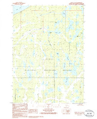
1986 Map of Kenai D-2 NE
USGS Topo · Published 1986About this map
The Kenai National Wildlife Refuge dominates this sub-arctic landscape on the Kenai Peninsula, characterized by a dense network of kettle lakes and slow-moving streams. Reached by Cook Inlet in the northwest corner, the territory is defined by its water systems, including the interconnected Vogel Lake, Kuguyuk Lake, and the expansive Bird Lake. A single Landing Strip and a north-south Pipeline corridor represent the primary human imprints on an otherwise non-industrialized terrain.
Find a feature on this map
22 named features on this map. Tap any name to fly to it.
Don’t see what you’re looking for? This feature index may not catch every label — zoom into the map to look around manually.
Map Details
Editions of this 1986 Kenai D-2 NE Map
This is the sole edition of this map. No revisions or reprints were ever made.
Other maps of this area

1944 · Kenai
USGS Topo · 1:250,000

1949 · Tyonek
USGS Topo · 1:250,000

1950 · Kenai
USGS Topo · 1:250,000

1951 · Tyonek
USGS Topo · 1:250,000

1951 · Kenai D-1
USGS Topo · 1:63,360

1951 · Kenai D-2
USGS Topo · 1:63,360

1951 · Tyonek A-2
USGS Topo · 1:63,360

1951 · Tyonek A-1
USGS Topo · 1:63,360

1952 · Kenai D-2
USGS Topo · 1:63,360

1952 · Tyonek A-2
USGS Topo · 1:63,360