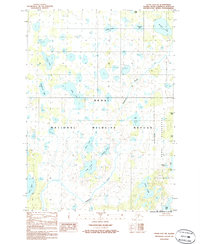
1986 Map of Kenai D-2 SW
USGS Topo · Published 1986About this map
Swanson River meanders through the heart of this landscape, a region defined by an intricate network of interconnected wetlands and glacial lakes. This mid-1980s survey captures the protected environments within the Kenai National Wildlife Refuge and the dedicated Kenai Wilderness area. The map illustrates a vast lacustrine system where named bodies of water like Tundra Lake, Mc Lain Lake, and Snowflake Lake are interspersed with smaller features such as Bufflehead Lake and Curlew Lake. The absence of roads or established trails highlights the preserved state of the Kenai Peninsula interior during this period. Researchers can observe the natural hydrology of the area, including the drainage patterns of Krein Lake and Sunrise Lake into the river system, providing a detailed look at the subarctic ecosystem before any modern recreational developments or infrastructure changes reached this section of the refuge.
Find a feature on this map
23 named features on this map. Tap any name to fly to it.
Don’t see what you’re looking for? This feature index may not catch every label — zoom into the map to look around manually.
Map Details
Editions of this 1986 Kenai D-2 SW Map
This is the sole edition of this map. No revisions or reprints were ever made.
Other maps of this area

1944 · Kenai
USGS Topo · 1:250,000

1950 · Kenai
USGS Topo · 1:250,000

1950 · Kenai C-3
USGS Topo · 1:63,360

1951 · Kenai D-3
USGS Topo · 1:63,360

1951 · Kenai C-2
USGS Topo · 1:63,360

1951 · Kenai D-2
USGS Topo · 1:63,360

1951 · Kenai C-3
USGS Topo · 1:63,360

1952 · Kenai D-3
USGS Topo · 1:63,360

1952 · Kenai D-2
USGS Topo · 1:63,360

1952 · Kenai C-2
USGS Topo · 1:63,360